

“Coastal residents are reminded that it only takes one hurricane making landfall to make it an active season for them. Thorough preparations should be made for every season, regardless of how much activity is predicted.” - Colorado State University hurricane forecasting team
On This Page
Hurricane Season 2026 May Predictions
Colorado State University's meteorological expert and eminent climatologist Dr Phil Klotzbach has published his team's latest pre-hurricane season predictions, which are a go-to source amongst scientists when it comes to assessing potential Atlantic hurricane activity in any given year.
May Storm Season 2026 Prediction Summary
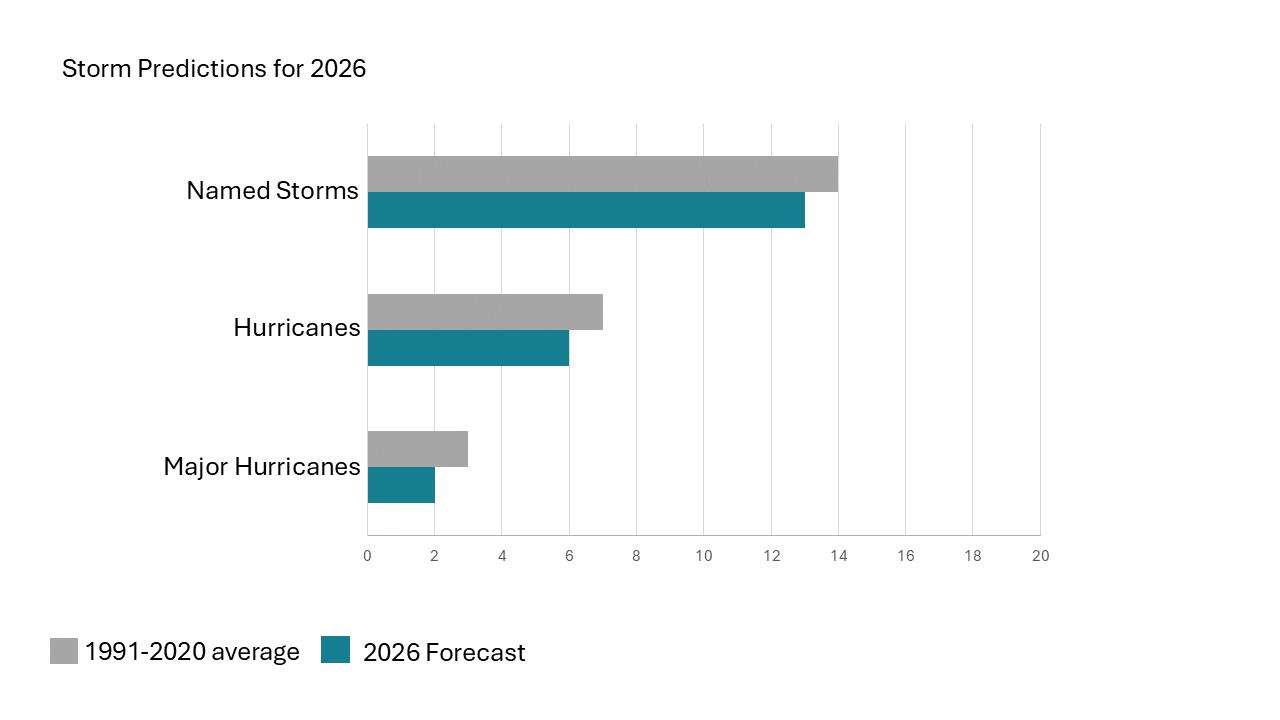
- The Atlantic hurricane season (June–November) is expected to be slightly below average this year, with 13 named storms, 6 hurricanes, and 2 major hurricanes (Category 3+)
- The main reason is the expected development of El Niño, which typically reduces hurricane activity in the Atlantic by increasing wind shear that disrupts storm formation.
- However, forecasts are uncertain. Past predictions have been wrong, and very warm ocean temperatures can override El Niño’s calming effect and still fuel strong storms.
- Current ocean conditions are mixed: warmer waters near the Caribbean could support more storms.
- Cooler central/eastern Atlantic waters could suppress activity.
- Climate change is also a factor, as hotter oceans can lead to more intense storms and rapid strengthening.
- While a quieter season is expected, conditions could still shift, and the final outcome remains uncertain.
- Probability for at least one major (Category 3–4–5) hurricane tracking through the Caribbean (10–20°N, 88–60°W) is 35% (Average from 1880–2020 is 47%).
You can read the full assessment of what to expect this storm season HERE.
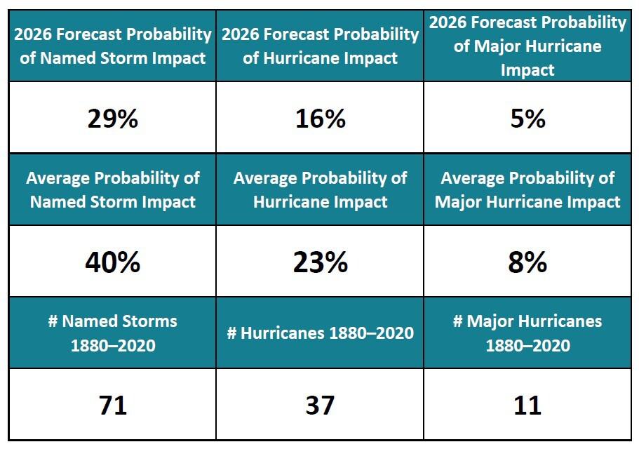
Cayman Islands Storm Impact Probabilities 2026
Since 2021, researchers at Colorado State University have estimated hurricane risk by looking at storms from 1880–2020 that passed within 50 miles of different regions across the Atlantic, including the U.S., Caribbean, Mexico, and Central America.
They use this historic data to calculate the chances of storms hitting or coming close, based on how often it’s happened before.
You can view historic storm tracks here: NOAA Historical Hurricane Tracks.
You can also see the full list of statistics for the US and the Caribbean here: CSU Tropical Cyclone Impact Probabilities
The table below shows the chances of a storm impact in the Cayman Islands in 2026 versus the yearly average. An 'impact' is defined as meaning one or more storms passing within 50 miles of the Islands.
Atlantic Storm Names 2026

2026 Tropical Storm Names
Home Insurance in a Hurricane Prone Region
Many hurricane preparations happen in the final days before landfall. Insurance decisions can thankfully be made much earlier. Reviewing your property and contents coverage during calm conditions allows time to ensure it reflects the true value of your home and belongings, particularly as building and replacement costs continue to rise. If your home is insured for less than its total rebuilding cost, and you make a claim, insurers may invoke a coinsurance clause, meaning you may receive a reduced payout, leaving you to cover the shortfall yourself. The providers below offer quotes and practical guidance on insuring property in a region where hurricane activity is on everyone's radar for about six months of the year!
More on insurance
Home Insurance
Your home is likely your largest financial investment. Therefore, it’s essential to protect it with the right home insurance coverage in the Cayman Islands.
Contents Insurance
Contents insurance in the Cayman Islands helps protect your personal belongings against loss or damage caused by events such as theft, flooding and hurricanes.
Summary of Cayman's 2025 Hurricane Season
The 2025 Atlantic hurricane season was above normal based on the number of major hurricanes and an Accumulated Cyclone Energy (ACE) of 132.9. ACE is a metric used by meteorologists to compare the overall activity of tropical cyclones. It is calculated by utilising the available records of windspeeds measured at six-hour intervals, in order to synthesise storm duration and strength into a single index value for comparison with other years. The climatological average for the last 30 years or so is an ACE of 123. At 132.9, the 2025 season was well above that.
The 2025 season produced 13 named storms, 5 hurricanes, and 4 major hurricanes, compared to the 1991–2020 averages of 14, 7, and 3. All four major hurricanes reached at least Category 4, and three, Erin, Humberto, and Melissa, became Category 5 storms.
Hurricane Melissa made landfall as a Category 5 in Jamaica, causing an estimated $6–$7 billion in damage, with additional impacts in Cuba and Hispaniola.
2025 was the second-most active season on record for Category 5 hurricanes (three), behind only 2005. No hurricanes and only one named storm made U.S. landfall, the first time this has happened since 2015. No named storms formed between 24th August and 16th September, which is also a rare occurrence last seen in 1992.
The 2025 hurricane season reinforced the importance of preparedness, early monitoring, and reliance on official guidance from the National Hurricane Center, NOAA, and Hazard Management Cayman Islands.
Whilst the Cayman Islands are a relatively small target in a vast ocean, history shows that even a brush with a tropical storm, let alone a hurricane, can cause significant damage and lead to power outages lasting several days. Category 3–5 storms are far less common, but those who experienced the impacts of major hurricanes in the past will attest to how devastating they can be.
Being prepared and having a plan well in advance is key to weathering the storm. Read on for all the information you’ll need to get you and your family ready for the 2026 Hurricane Season, which begins on 1st June.
Hurricanes in Cayman 101
Hurricanes are measured using the Saffir–Simpson Hurricane Wind Scale, but this scale is not a reliable indicator of overall impact. The category assigned to a hurricane reflects wind speed only and does not account for other critical factors such as the size of the wind field, the angle at which the storm approaches, or its forward speed. For this reason, it is essential to stay informed through official local information sources, including Radio Cayman, the Cayman Islands National Weather Service, Hazard Management Cayman Islands (HMCI), and other Government advisories whenever a hurricane is threatening.
These additional factors play a major role in determining storm surge, which is often the most significant threat to life and property during a hurricane. Grand Cayman and Little Cayman are predominantly low-lying islands, making them particularly vulnerable to storm surge flooding. In extreme, though rare, cases, hurricanes can cause sea levels to rise dramatically above normal levels. In addition to storm surge, hurricanes are usually accompanied by very large and powerful waves, which represent a separate and serious hazard.
Waves pose a real danger for coastal residents along open coastlines, as opposed to those living along canals. Most properties located directly on the coast are vulnerable to wave and surge impacts during a hurricane. However, many people are unaware that storm surge can also affect residents living well inland, particularly those in single-storey buildings located in low-lying areas. In a worst-case scenario involving a very large and powerful hurricane, even a ground floor situated 10 feet above sea level could be completely inundated by storm surge, potentially trapping occupants inside.
If the Cayman Islands experience a significant hurricane impact, residents should plan to be without electricity and water for a minimum of seven days, and potentially longer. After Hurricane Ivan in 2004, electricity took several weeks to be restored to most areas, and water supplies were disrupted for an extended period. During that time, banks, supermarkets, and gas stations were closed for at least a week. It is therefore vital to maintain an emergency supply of non-perishable food and water sufficient for at least one week per person. A general guideline is to store one gallon of water per person per day, kept in a cool, dark location. A portable radio with extra batteries is also essential, as radio often remains the most reliable source of information when internet, television, and mobile networks are unavailable.
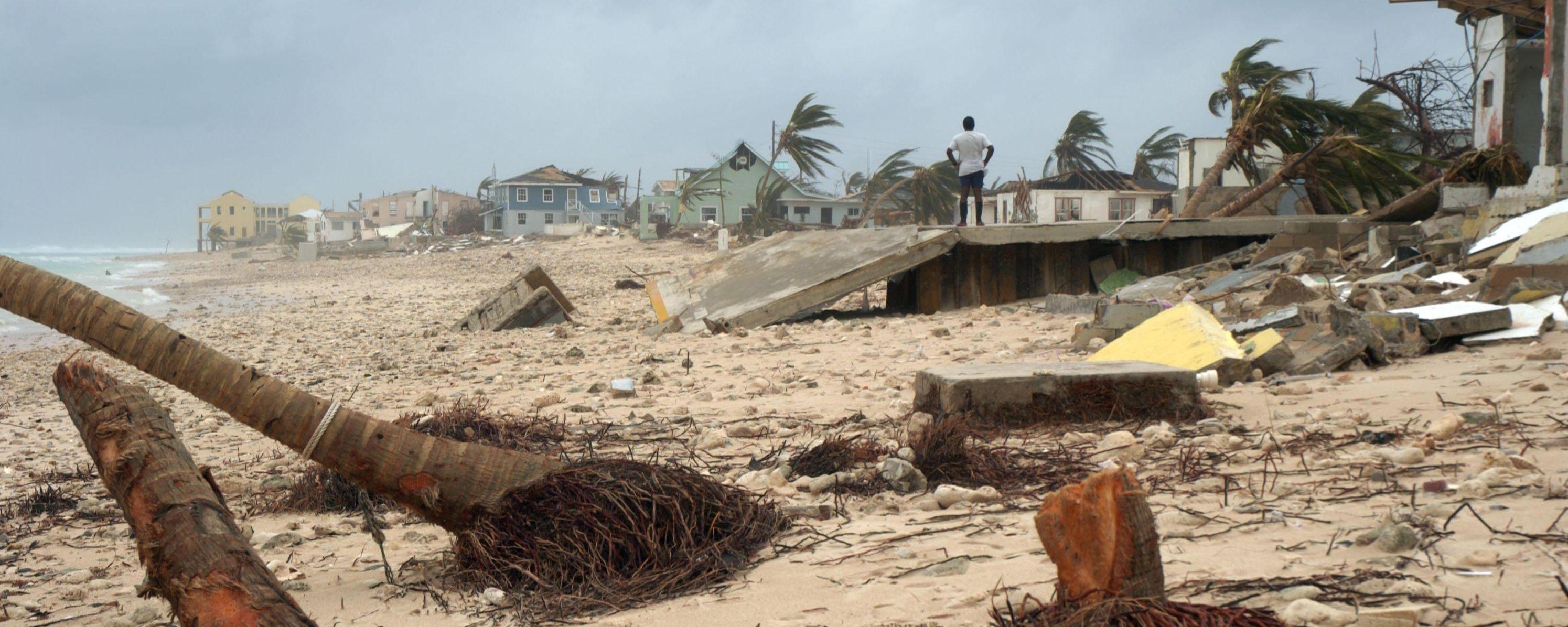
Hurricane Ivan wreaked havoc on the Cayman Islands in 2004
The Cayman Islands Government maintains a dedicated department responsible for disaster preparedness, including hurricanes. Hazard Management Cayman Islands (HMCI) works with businesses, schools, community groups, and other Government departments to provide guidance on preparedness and response. HMCI’s website is regularly updated with information on named storms and other hazards, as well as advice for the public.
Preparation is key. Install hurricane shutters or ensure plywood is available to cover openings before hurricane season begins. Once wind breaches a building, internal pressure increases and the roof is far more likely to fail. It is too late to think about protecting personal belongings, securing important documents, filling vehicles with fuel, or purchasing supplies once a hurricane is imminent. It is also advisable to withdraw sufficient cash in advance, as ATMs may not function, banks may restrict withdrawals, and personal cheques are unlikely to be accepted after a storm. Prepare an evacuation “to-go bag” containing important documents stored in waterproof bags, along with clothing, food, water, medications, and other essentials for at least five days per person. Please refer to our checklist for a full list of recommended supplies and preparation steps.
Decide in advance where you will stay during a hurricane. If your home is elevated, well-constructed, and outside known flood and wave impact zones, it may be the safest option. Speak with neighbours about the vulnerability of your area to flooding or wave action, or contact Lands and Survey to obtain a topographical map of your property. If you determine that it is safe to remain at home, identify the most secure interior areas for shelter and plan possible escape routes.
If your home is not secure, then evacuate! Low-lying areas will flood, so take shelter on higher ground at your workplace or a friend’s house. Hurricane shelters are also an option; a complete list of locations can be found on the Hurricane Shelters page. Remember, ambulances will not be running during a hurricane, so if you have a health issue that may require medical attention it is best to go to an Emergency Medical Centre (EMC) shelter.
Hurricane Checklistkeyboard_arrow_right
Supplies, important document safety, pre-storm to-do list and even leaving the Island on a temporary basis. We thought of it so you don't have to.
Read MoreHurricane Scale and Flagskeyboard_arrow_right
Know the signs, warnings and the meaning behind the flags.
Read MoreHurricane Shelterskeyboard_arrow_right
Know where to go in Cayman if the risk posed by a tropical storm or higher is just too great to remain in your own home.
Read MoreHurricane Shutterskeyboard_arrow_right
Shutters are an excellent investment for homeowners, adding that extra level of security to your property when you are off-Island, and most importantly, peace of mind during hurricane season.
Read MoreMedical Assistance During a Storm
Every district has a shelter that is specifically designated as an Emergency Medical Centre (EMC). If you have an existing medical condition, this may be the best place to seek shelter because there are medical personnel on hand. During high winds or flooding, however, ambulances will not respond until it is safe, which could potentially be more than 24 hours later. Make sure that your health insurance is up-to-date, so you are covered in the event of a medical emergency.
Visit the Hurricane Shelters page for a list of the designated emergency medical centres so that you can plan ahead of time the best course of action for you and your family. Also check out our Health Services page for more on medical services in the Cayman Islands.
Caring for the Vulnerable
Children & the Elderly
Young children and the elderly are vulnerable during a storm and, without support, can suffer great emotional distress. If you have an elderly friend or relative, consider offering your home as a safe-haven. If they are in a nursing home, be sure to confirm their emergency plans. If accompanied by an elderly person, keep in mind that they may take daily medication. Ensure that there is a sufficient supply and that it is stored in watertight containers. Young children may need special items, such as diapers, formula and bottles.
Medically Challenged & Disabled
If you have someone in your family with a serious medical condition or disability, consider leaving the Island with them prior to a serious hurricane hitting. If this is not possible, consult with a medical professional who is familiar with your loved ones medical history in order to receive tips on how to keep them as healthy as possible during a high stress situation. Also, if they are reliant on special medication, ensure you have an ample supply on hand.
Pets
There are only two pet-friendly shelters on Grand Cayman and there is limited capacity. Space will be allocated on a first-come, first-served basis. Refer to our Looking After Your Pets page for helpful information on how to protect your pets during a hurricane.


